Ruth Ann Stacey and I met on the 2014 Glacier Tour, Ruth Ann’s first foray into the world of CCCTS cycling. She’s a tiny dynamo; with loads of energy, many anecdotes to spin, and a most pleasant lass to ride, eat or drink with. She expressed an interest in organizing a CCCTS-sponsored event in her adopted Washington State (she hails from Pennsylvania); and specifically in Kittitas County (created in 1883 with Ellensburg as the County Seat; the current population is about 42,000, and is the home of Central Washington University), which begins in the Cascades and runs east covering 6 000 km². Her enthusiasm to present her Valley to a CCCTS audience was obvious. She made it plain the number of participants for her special week mattered not at all: all she wanted were enthusiastic cyclists who cared not a whit if the winds blew, and that they were interested in learning about her treasured Valley. A year later I had the good fortune of having Max McClanahan as travel- and room-mate. The early morning ferry crossed the Salish Sea with the Cascades appearing as a defensive line to the east; Mount Baker was in full splendour; Mt. Rainier, gleamed off in the distant west. We’d soon be travelling through this range to reach Ellensburg.
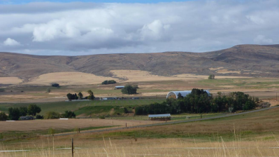 Why had Ruth Ann singled out wind as a variable of concern? The Valley has the Cascades as a northwest barrier to the Pacific Ocean. Oceanic winds frequently whistle over these peaks, and in so doing stir up the warm dry air in the Valley below. The winds tend to be more quiescent in fall than in spring; hence, this September event. As often is the case “… the best laid plans o’ mice an’ men …” tend to go awry; our first ride day had us on the west side of the Valley – the morning winds gusted to greater than 35 km/hour. Pace lines were the order of the day as we passed by farmers finishing their final hay harvest of the year. The Valley’s convoluted and precious irrigation systems along with the drying winds, allows for two to three crops of valuable Timothy hay per year. The bulk of the crop goes to Japan where, if harvested when green in colour, fetches five-times the price of yellow hay: nothing is too good for their racehorses and prized beef cattle.
The Valley is “eye candy” for geologists. Following our first day’s ride, using Ruth Ann’s superb map (she not only developed greater than 10 route maps and cue sheets, but she independently cycled each route) we hosted University of Central Washington’s award-winning geologist, Dr. Nick Zentner (his educational videos are available on U-tube) at Happy Hour. He came with no prepared lecture; when you’re a gifted speaker with an in-depth knowledge of the topic notes are unnecessary. He had us describe the geological observations of this, our first day, and he’d attempt to craft a narrative that explained the sights. It worked. We’d been observant, and were able to set the stage. Nick quickly zeroed in on the Cascades, their origins and the role ocean floor spreading played in creating these behemoths (the action of the Pacific Plate subducting under the North American plate). He described a hotspot on the latter plate east of the Kittitas Valley and its role, along with ocean floor spreading, in the formation of a succession of volcanoes that, over 25 million years, distributed lava deposits in places greater than three kilometres thick. Later he described huge ice age (15,000 to 25,000 years ago) dams in Idaho that contained and released water over 300 times. The ferocious currents sculpted the landscape as they roared their way to the Columbia River north of Wenatchee. Cascade glaciers from this period did play a role, however, in sculpting the Kittitas Valley, one, stopping just north of Thorpe that formed drumlins and moraines that we were later able to recognize as we rode in the Valley’s northwest quadrant. As well, we were told to watch for “lahars”, features made of white volcanic ash that locals yet persist in calling “sandstones”. As a reward to fighting the winds on our Wednesday ride to Cle Elum, Ruth Ann urged us to arrive hungry. She wanted us to enjoy to the fullest, the delicacies awaiting us at “Smokey’s”, a regionally famous bbq restaurant. I found myself in the company of a rider brand new to CCCTS, Jim Cilek. We fought the wind. We climbed the hills. We talked of succulent barbecued joints. Entering the village we met up with Ruth Ann who led us to Smokey’s. Ominously cars absented the parking lot. No cheerful souls sat on the sun-filled decks. The dark restaurant interior appeared dark. An irritating sign on the door stated: “Fall hours; open Thursday to Sunday.” A huge disappointment it was that rendered some of us speechless, and those that weren’t wished they had been. Worst of it was Ruth Ann, excellent organizer that she is, had called Smokey’s the previous day. A voice message ensured callers that “summer hours” prevailed. Uh huh! We settled for very ordinary sandwiches at the Bakery House. The fast ride back with Jim, George and Jeanetta had road-cuts that oozed geology; and in particular there were thick layered lahars exposing themselves as we headed home to Ellensburg.
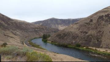 The Yakima River wends its way south from Ellensburg to Yakima. As we rode this spectacular river valley we were flanked by towering hills formed as “uplifts” due, once again, to the collision of the Pacific and North American Plates (thanks Ruth Ann for the onsite observation. Shortly after explaining this phenomenon to us, she went home to can tomatoes). Again, the rode cuts told the geological story with nicely defined layers of gnarly basalt. As an aside, Kumiko and I drove this road some years back, bound for the Bend H&S; we agreed, this delightful Yakima River route could form the backbone of an H&S or tour. This particular H&S day was overcast. We wore full-fingered gloves. For most of us, legs were covered. We climbed the ascents. We soared down the descents. It was exhilarating. Fishers were casting flies in the river below. Pastoral and peaceful would describe the scenes. However, all was not well. Wildlife specialists with scopes were spotting sheep. We learned the local wild sheep population had been infected with a lethal virus for which there is no vaccine. The current survival rate for young-of-the year lambs was one in twelve. The population was crashing. The disease had spread from a domestic herd whose owner had not tended to the health of his flock. This news further darkened an already grey day; the ride back was in drizzle. Again, we pace-lined. Later, a wee dram of rum warmed our tummies, but did little to ease our guilt for the impact man has on the world’s ecosystems. The day was capped at The Ellensburg Pasta House, where the fine fare was washed down with Rick Mathias-supplied red wine.
Leavenworth, tucked into the Cascade Range, was the H&S’s penultimate ride. Why was a Chelan County town billed on a Kittitas County tour? The beauty of the ride, and the setting of this picturesque former mining town explained it. As is so often the case with Pacific Northwest resource-based towns, the mineral and timber resources dwindle and the towns die a slow death. Not Leavenworth. The setting depicts Bavaria, and Bavaria it will be. Presto, with much planning and hard-work, it is now a “Bavarian” look alike, and appears to be prospering. Yes there are the facades, the many, many look-alike crafts and gift stores, but this town seems to have planned well. The food was good. The beer authentic. The piped Bavarian “oom pah pah” music a little tedious. Our resident musician, Bruce Daykin, said he’d “… like to meet the accordion player.” It was a fun destination. I even bought a senior’s plaque for a very close senior friend, “We’ll be good friends ‘til we’re old and demented, then we’ll be good new friends.” Yikes! The atmosphere had won me over. And the scenery; well it was Bavarian. Maybe better than Bavaria. Ron, Deborah, Max and Ted took the original road/trail into the area and back (a steeper and longer climb). The rest of us 7 swooped downhill for kilometres on the highway into the village. We hardly swooped heading back. The climb was gradual and long. Our Chinese restaurant that evening was not a stellar choice; we chose Chinese to appease Gwenda and her desire for vegetables. Chinese yes; this restaurant, no.
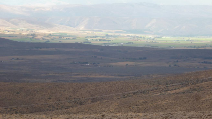 The next day had us on the “Best of the East Side” route, and indeed it was a splendid way to end the tour for some of us. The west and north vistas were spectacular; we looked across picturesque farms and onto Ellensburg, sitting at the lowest point in the Valley. The Cascades, and in particular the Stewart Range, were well defined in the morning sun. Later Ted, Max, Deborah and Ron rode directly northeast to the “Wild Horse Wind and Solar Facility run by Puget Sound Energy’s Renewable Energy Centre (REC). Some of us followed “one-speed-fast-forward” Ruth Ann back to Ellensburg. We averaged about 35 km/h for about 12 km. The Childs on Bike Fridays found their own way home. Some of us drove back to the REC to join the site tour. It was well worth it. With 149 wind turbines the farm has the capacity to generate power for about 300 U.S. homes.
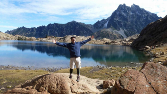 Not only is Ruth Ann a long time, and accomplished cyclist, but she’s a hardened hiker who’s more frequently hiking in the cascades than cycling in the Valley. Interestingly, sightings of local cyclists in the Valley were rare during our time there. It may be the winds; it may be the culture of farm folk who work too hard to jump on a bicycle on days off. Hence, Ruth Ann offering a hike to visiting cyclists was not surprising. Friday morning had Max, Bruce and me rising at 5:30 a.m., picking up Ruth Ann and driving 90 minutes north to the Cascades-located Ingalls Lake Trail head. The morning was cool. The trail was damp from overnight rain. We hiked. The sun appeared. The backpackers we met with wet
 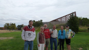 tents welcomed the rays. Three hours it took us to reach the scenic Lake, where the sandy bottom presented little sign of life. There were signs of fish rising offshore, however. Abalone coloured serpentine rock dominated the boulder fields around and down from the Lake. We lunched and descended. Our ascent was about 800 m and the distance about 16 km. A few hours later, at the group dinner, we were thanking Ruth Ann for her well organized and interesting H&S; an exemplary job she did. We now wait patiently for Ruth Ann to
organize a Cascades tour.